
Archaeologia Lituana ISSN 1392-6748 eISSN 2538-8738
2024, vol. 25, pp. 206–220 DOI: https://doi.org/10.15388/ArchLit.2024.25.8
Viktor Vietrov
State Historical and Cultural Reserve “Mezhybizh”
Medzhybizh, Ukraine
vetrov.poryad@gmail.com
https://orcid.org/0000-0001-6948-7599
Abstract. We represent the results of archaeological works by using the drilling method. Such works were carried out in Medzhybizh and Bar castles, as well as in Palaeolithic field explorations. Our drilling research in castles focused on the inspection of courtyards and fortification of castles. Drilling made it possible to see the thickness of cultural layers up to 8 meters of thickness. Based on the obtained data, reconstructions of the daytime surface of castle courtyards and the sequence of changes in their relief were carried out. Drilling during the search for Palaeolithic sites was carried out on turfed areas and different soil types. High efficiency of exploratory drilling operations has been determined. The equipment was adapted, and the optimal drilling technique was worked out during archaeological explorations.
Keywords: drilling methods, Medzhybizh, Bar, castle, Palaeolithic.
Anotacija. Straipsnyje pristatomi archeologinių tyrimų Medžybižo ir Baro pilyse bei paleolito laikotarpio radavietėse taikant gręžimo metodą rezultatai. Gręžinių pilyse tikslas – pilių kiemų ir įtvirtinimų tyrimai. Gręžimo metodu nustatytas iki 8 metrų storio kultūrinis sluoksnis. Remiantis gautais duomenimis, buvo atlikta pilyse buvusios kiemų dangos rekonstrukcija ir nustatyta jų reljefo istorinė raida. Paleolito objektų paieška atlikta taikant gręžimo metodus durpingose teritorijose ir įvairių tipų dirvožemiuose. Nustatyta, kad gręžimas yra itin efektyvus paieškų metodas. Archeologinių tyrinėjimų metu įranga buvo pritaikyta ir nustatyta optimali gręžimo technika.
Reikšminiai žodžiai: gręžimo metodai, Medžybižas, Baras, pilys, paleolitas.
__________
Received: 27/09/2024. Accepted: 04/12/2024
Copyright © 2024 Viktor Vietrov. Published by Vilnius University Press. This is an Open Access article distributed under the terms of the Creative Commons Attribution License, which permits unrestricted use, distribution, and reproduction in any medium, provided the original author and source are credited.
The modern experience of archaeological work using drilling has many practical directions. The most common use of drilling works is for the general geomorphological description of the archaeological site. Geologists with experience of working on archaeological sites are engaged in this field, for example, the company Wessex Archeology (Great Britain; Wessex Archeology, 2017) Another direction of drilling works is non-invasive research of powerful cultural layers. A positive example of such works is the study by Vilnius University employees of earthen archaeological sites of the 13th–14th century near Kernavė Castle in 2018–2019 (Vengalis et al., 2020). An example of multidisciplinary research using drilling operations, which contribute to discovering an archaeological object, is the study of the Roman Iron Age settlement site near Skudeniai by our Lithuanian colleagues in 2020. This site was located in the gas pipeline construction zone (Vengalis et al., 2022).
In addition to multidisciplinary research on previously discovered sites, exploratory drilling is used to uncover new archaeological sites. In the global planning of the search for archaeological sites, this can be regional drilling for geomorphology, the study of existing cores to detect specific soils, and the presence of artifacts in the cores. Such works were carried out by Ukrainian archaeologists in the context of searching for submerged monuments in the Black Sea shelf (Kadurin et al., 2020). Another option can be complex drilling in specific areas, the purpose of which is to clarify the geomorphological composition of the area of archaeological exploration, as well as targeted drilling for artifacts. An example of such works is the Polish project “Exploitation and Processing of Chocolate Flint during Palaeolithic and Mesolithic in the North-Western Part of its Deposits Based on Non-Invasive Archaeological and Geophysical Research and Test-Trenches.” Its task includes both clarifying the geology to find areas of ancient flint raw materials and drilling directly in the discovered areas of Palaeolithic-Mesolithic flint raw materials to retrieve artifacts (Instytut Archeologii i Etnologii Polskiej Akademii Nauk, 2017).
Drilling as a method of obtaining information on the dating and taphonomy of cultural layers was implemented by an international team of researchers at the Simons Cave Palaeolithic site (Republic of South Africa; Colarossi et al., 2022). The aim of their research was to compare the completeness and quality of the data obtained by non-invasive drilling with the data from the control excavation. The authors provided sufficient and suitable factual material on the specifics of dry soil drilling and using different sleeve inserts, depending on the type of the core that must be obtained as a result of the work.
Drilling is used as a non-invasive method of research on already discovered archaeological sites. To a lesser extent, drilling is used in exploratory archaeological work. The advantages of drilling at archaeological sites are evident: the non-invasiveness of studies of embankments and the possibility of multidisciplinary research. Hence, the same core can provide material for soil micromorphology, its density, humidity, spore-pollen samples, and organics for radiocarbon dating. If ten or more drilling wells with depths of 5–15 meters are drilled simultaneously, then we can talk about the financial profitability of such works compared to drilling to the same depths. The disadvantages of this method include the relatively high cost of drilling operations, which requires the use of actual industrial (or specialized) equipment and the work of professional drillers. Our experience of conducting drilling operations during the search for archaeological monuments and their stationary research provides an opportunity for a new perspective on the application of traditional technologies and prospects for their development.
Manual and mechanized drilling is used in archaeological practice. Mechanized drilling used on archaeological sites is divided into impact, rotary, and vibration. The name of each strategy indicates the method of piercing the soil and the principle of the action of the drill. The most popular method is rotary drilling. It is characterized by efficiency, simplicity, and economy. Rotary drilling is screwed, core or rotary.
The most popular method (specifically, auger) involves the destruction of rock with auger blades that are screwed into the soil. Blades push the soil outward. Their angle can be from 30 to 90 degrees. The angle is determined depending on the type of soil. At the same time, it should be taken into account that part of the soil remains in the drilling well. This method is effective for drilling in soils to a depth of up to 30 m (Fig. 1b). The advantages of auger drilling include the speed of work, the relative simplicity of the equipment design, and the removal of soil from the well at the time of drilling. When conducting auger drilling with a hand tool, it is possible to form a well in a limited space (for example, in the basement of a castle) (Fig. 1c). The main disadvantage of auger drilling is its problematic use in loose soil.
The core drilling method is effective for sandy and clay soils. The soil is not crushed during the drilling process but is extracted with a whole intact core (Fig. 1d). Drilling takes place with the help of a crown placed at the end of a pipe. In mechanical drilling, the core drilling method is recommended for creating deep wells (Fig. 1a). The advantages of this drilling method are high productivity, speed of operation, and the ability to drill a well of a large diameter.
Fig. 1. Drilling methods during archaeological work: a) mechanical drilling, the core drilling method (Medzhybizh Castle, 2015); b) mechanical drilling, the auger method (Medzhybizh Castle, 2017); c) manual drilling, the auger method (exploration, 2019); d) manual drilling, the core drilling method (exploration, 2022); e) mechanical drilling, the hammering method (exploration during road construction, Lincoln, Nebraska State, USA) (sourced from: https://nebraskaarchaeology.org/tag/soil-core/).
1 pav. Gręžimo metodai archeologiniuose tyrimuose: a) mechanizuotas kerno ištraukimas (Medžybižo pilis, 2015); b) mechanizuotas sraigtinis gręžimas (Medžybižo pilis, 2017); c) rankinis sraigtinis gręžimas (žvalgymai, 2019 m.); d) rankinis kerno ištraukimas (žvalgymai, 2022 m.); e) mechanizuotas kalimas (žvalgymai tiesiant kelią, JAV, Nebraska, Linkolnas) [nuotrauka]: (https://nebraskaarchaeology.org/tag/soil-core/).
The shock-rope drilling method is relevant for work on sandy, clayey and viscous soils. The work uses a bailer and special devices for hammering movements (Fig. 1e). A drilling well is formed with the help of blows on the soil, and, after each blow, the auger rises outward and retrieves the soil. The advantages of this drilling method are the ability to use it on different soils and its cheapness in terms of equipment compared to the drilling core method. Percussive methods also include hammer drilling. Pipes of various diameters and lengths are used in the work, which are driven into the soil with the help of mechanical or manual devices and then removed together with the soil. The advantage of this method is the relatively intact core if it is taken into a sleeve or a specialized soil receiver. However, this drilling method uses complex and expensive equipment. If hammer drilling is carried out in a standard drill pipe, the soil is crumpled and becomes very dense, and problems arise with its extraction, due to which, artifacts in the core may get damaged.
The rotary, or rolling, method of drilling involves the destruction of the soil with a chisel and its removal from the drilling well by flushing. Due to the destructive nature of the drilling method, it is not used in archaeology.
Drilling in archaeology partly coincides with the standard choice of drilling methods for geological exploration, but there are some specifics. In our practical work, we tried combining three drilling methods.
The first type is total – or ‘strategic’ – drilling, which involves drilling wells up to 15–50 meters of depth. It gives an idea of the general geological picture of the research area. During reconnaissance work covering a territory of more than tens of square kilometers, this method shows the general geological structure of the site and the types and thickness of Quaternary deposits. Such data is used as a basis for field reconnaissance planning. It allows the application of geological data (for example, see Fig. 4.a; Завгородний, Коваленко, 1965) with further verification by field drilling if geologists have already worked on the investigation site. Strategic drilling is carried out mainly by the core method, with drilling rigs on a car chassis. It is an expensive method, and it applies as a basis for a long-term study of the region. Sometimes, this type is used for a separate research object. For example, we used it as a starting point for a comprehensive survey of Medzhybizh Castle (Жадан, Ращенко, 2017).
The second type is detailed drilling involves drilling wells of 5–15 meters of depth to obtain stratigraphic profiles of the research area. Stratigraphic data from detailed drilling is applied to verify and refine the data from strategic drilling obtained from geological reports and the deciphering of cartographic materials. Thus, this stage is performed directly by archaeologists or drilling specialists on the technical task of archaeologists. This drilling is limited to specific objects (medieval castles or cities). The purpose of drilling is to find out the thickness, area, and the technical data of the cultural layer, which can be several meters thick. Such studies are necessary for planning the excavations and test pits (as they may lie at a depth of five or more meters). The selection of samples from the core for the technical properties of soils is necessary to plan drainage systems from the surface of excavations and the research object. For detailed drilling, depending on the assigned technical task and the amount of its budget (i.e., financing), auger, column (and sometimes hammer) drilling methods can be used manually, or with a mechanical drilling rig. We used detailed drilling in the investigation of the medieval castles in Medzhybizh (Гарник, Віславський, 2016) and Bar (Язвінський, Олійник, 2021), as well as in the investigation of the medieval city of Medzhybizh (Пустовєтов, 2019). This drilling type is relatively inexpensive, and it applies to comprehensive research of a specific object.
The third type is exploratory drilling. It is the most common and widely used type in field archaeological research. Drilling wells are 1–5 meters deep. The purpose of drilling is to obtain artifacts from the cores of the cultural layer, as well as detailed stratigraphic data.
We think it is possible to expand the use of drilling techniques in the long term when one archaeological team uses several types of drilling in its practical work. Our studies, where drilling was used, include two groups of archaeological sites. The first group is a study of castles located in Medzhybizh and Bar in the West of Ukraine. The second group is field reconnaissance in search of Palaeolithic sites in the East of Ukraine (Luhansk Region) and in the West (Khmelnytskyi Region).
Medzhybizh Castle is located on a high hill between two rivers: the Pivdennyi Buh and the Buzhok. Its coordinates are 49°26′11″N 27°25′07″E. The first wooden and earthen fortifications were erected here in the 12th century. The stone fortification of the Castle appeared in the second half of the 14th century. By the middle of the 17th century, the castle was upgraded. From the 18th century onwards, it lost its military significance. During the 18th and 20th centuries, the castle was used for economic purposes which were associated with significant architectural and landscape changes. Currently, the Castle looks like an elongated pentagon measuring 100×150 meters. The Castle has stone walls around the perimeter, five towers, two palace buildings, a church, a bridge, and outbuildings.
The primary scope of archaeological information is related to the excavations of O. Avagyan, Yu. Tolkachov, and O. Pohorilets, which took place from 1985 to 2014 (Толкачов, 2010). The objects were investigated with the help of test pits and excavations. However, the use of such data is limited due to insufficient registration of stratigraphy, lack of soil lithology, small volume and poor quality of photo-fixation. In addition, the basic geological information of the attraction is missing. In 2015, at the beginning of emergency and restoration work in Medzhybizh Castle, the restorers posed several questions to the archaeologists. Most of them focused on clarification of the scope of the anthropogenic influence on the natural relief in different areas of the Castle. They were also interested in the conditions of formation and thickness of the cultural layer in the Castle and its influence on the existing architectural and fortification objects. To solve these issues, we have developed the task of drilling wells in one system together with archaeological pits. Thus, based on the drilling results, we were to obtain a series of stratigraphic sections through which we became aware of the thickness of the cultural layer of Medzhybizh Castle (Fig. 2). To carry out the stratigraphic research program, investigation of the soil types, the geology of the natural relief, and water-saturated horizons levels, we drilled 22 drilling wells, and also dug more than 30 test pits on the territory of the Castle.
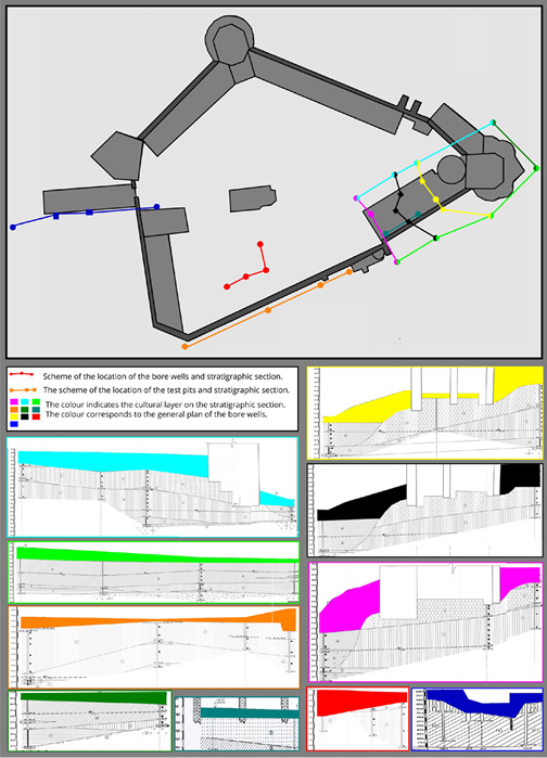
Fig. 2. Castle in Medzhybizh. Location scheme of drilling wells, test pits and stratigraphic profiles. The color indicates the thickness of the cultural layer on the corresponding profile.
2 pav. Pilis Medžybiže. Gręžinių, šurfų ir stratigrafinių profilių išdėstymo schema. Spalva nurodo kultūrinio sluoksnio storį atitinkamame profilyje.
Boreholes outside the buildings were drilled by mechanized drilling with an auger on a car chassis. The diameter of the boreholes is 200 mm, and the depth is up to 18.5 m. Parts of the boreholes outside and whole boreholes in the middle of the buildings were made manually with a drilling core. Its diameter is 75 mm, and we reached a depth of up to 12 m. The test pits were laid up to six meters deep. Analysis of the cores from the drilling wells made it possible to compile ten basic stratigraphic profiles (see Fig. 2). The details of the stratigraphy of the upper horizons were clarified by the test pits. As a result, for the first time since the beginning of archaeological work in the Castle, the thickness of the cultural layer was determined, reaching 8–11 meters in some places. This information formed the basis of the planning of archaeological and restoration works.
The Castle is located on the banks of the Riv River, near the town of Bar. Its coordinates are 49°04′25″N 27°40′00″E. The construction of the first regular fortification on the Castle’s territory dates back to the middle of the 16th century. The name of the town and the Castle was given by the Queen of Poland and Grand Duchess of Lithuania, Bona Sforza, in honor of her native town in Italy. The next stage of upgrading Bar Castle was implemented in the 17th and 18th centuries. The Castle fortification is represented by a bastion fortification built on a rectangular polygon with four bastions. The Western front, facing the river, has a Redan projection in the middle. The size of the Castle is 160×190 meters (Пламеницька, 2005, 104).
The first attempt at archaeological research of the Castle was conducted by L. I. Vynohrodska in 2007. Two trenches and three test pits were laid. As a result, masonry fragments and artifacts of the 16th and 19th centuries were recorded. Significant data on the planning, architecture, and stratigraphy of the cultural layers of the Castle were not obtained. The next stage of archaeological research was conducted by P. O. Nechytaylo in 2020. It was planned to dig four shafts from outside the Castle walls. The task was to find out the lower level of laying the walls. The size of the test pits was calculated for a depth of up to three meters. In two shafts, the bottom of the masonry was found at this depth. However, the depth of the two test pits was 5–6 meters. It led to a redesign of building pits, the use of earth-moving equipment in the work, and an unplanned increase in the funding of the work. The result of the work was insignificant. It became clear that the Castle had several meters of external layering of soil and construction debris. The information from the test pits was not sufficient for further planning of archaeological and architectural research. The lack of detailed plans of the Castle at the beginning of the study did not make it possible to correlate the stratigraphic data of the test pits in absolute heights.
After that, the management of the “Barsky Castle Renaissance” foundation asked us to develop a research program for Bar Castle based on the experience of working in Medzhybizh Castle. Such a program was developed. In the first stage, it conditioned the drawing up of a plan for a detailed topographical survey of the Castle for the precise reference of all archaeological and geological works. The second stage involved drilling a series of wells in those areas of the terrain that could provide the maximum stratigraphic information about the bastion fortifications or the parameters of the cultural layer between them. According to the technical task drawn up by us, the geologist O. Yazvinsky laid 12 exploratory wells with depths of up to 10 m (Язвінський, Олійник, 2021). Based on the results of this work, six detailed stratigraphic sections of the bastions and the central part of the Castle were created (Fig. 3). On the grounds of these data, a plan for comprehensive archaeological research of the Castle was formed.

Fig. 3. The Castle in Bar. Location scheme of drilling wells, test pits and stratigraphic profiles. The color indicates the thickness of the cultural layer on the corresponding profile.
3 pav. Baro pilis. Gręžinių, šurfų ir stratigrafinių profilių išdėstymo schema. Spalva nurodo kultūrinio sluoksnio storį atitinkamame profilyje.
Optimizing the search for archaeological monuments in the surface areas covered with turf soil (sod) with a limited amount of lifting material, or its absence at all, is an urgent task of field archaeology. To solve it, we used different drilling methods. The works were carried out during the search for sites of the Early Palaeolithic from 2012 to 2014 in the East of Ukraine in the middle course of the river system of the Siverskyi Donets. After the beginning of the armed conflict in the East of Ukraine, the program continues in the West, in the Pivdennyi Buh River basin.
The first stage of work from 2012 to 2014 was carried out in the Luhansk Region. In 2012, during Palaeolithic explorations near Pionerske village (now, renamed as Sukhodil village), drilling was attempted in the watersheds of the Siverskyi Donets River (Ветров, Кармазиненко, Маничев, 2013, 51–59). Under conditions of heavy loams, drilling was carried out with a manual core drill with a crown with a double tooth row. Drilling was conducted with a constant load of 40 kg of ballast on the drill gate. The drilling rate was about 1 meter per hour. It is faster than digging test pits but still time-consuming. The drilling was carried out to clarify the data on strategic drilling of palaeosols in the watersheds, according to the data from the geological survey of 1965 (Fig. 4а) (Завгородний, Коваленко, 1965).
In 2013, Palaeolithic explorations were carried out near Gerasimovka village in sods and ploughed areas of soil. Drilling was carried out on sandy soils and light loams to a depth of 1–1.3 m with a manual auger. The goal was to retrieve artifacts directly from the stratified horizon. The drilling rate was about 1 meter in 15–20 minutes. It is faster than digging test pits. This method makes it possible to lay up to 20 wells during one field day. In 2014, test pits verified the drilling data. According to working results, stratified areas of the cultural layer of the Early Palaeolithic were opened on the sodden surfaces (Fig. 4b,c) (Vetrov, 2015).
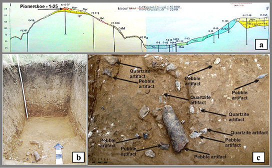
Fig. 4. Exploratory drilling in the search for Palaeolithic sites in the watersheds of Siverskyi Donets River: a) strategic drilling scheme of the watershed and the area of exploratory drilling; b) after the presence of Palaeolithic artifacts was confirmed by drilling, a test pit was laid in the sod areas; c) Early Palaeolithic layer in the test pit.
4 pav. Žvalgomieji gręžiniai ieškant paleolito radaviečių Doneco upės baseine: a) žvalgomųjų gręžinių išdėstymo schema; b) gręžiniais aptikus paleolito dirbinių, kasamas archeologinis šurfas; c) ankstyvojo paleolito kultūrinis sluoksnis šurfe.
The second stage of work began in 2015. It is related to the study of the Early Palaeolithic sites in the upper course of the Pivdennyi Buh River. Manual auger drills with one rod (1.3 m long) were used for exploration. Moreover, a drill with two nozzles (a cup and an auger) and rods with a total length of 6 m were manufactured. In addition, 1–2 section hammering drills from pipes with a diameter from 70 to 110 mm were used for our experiments. Some of this equipment was modernized over time. All drilling exploration works for the Palaeolithic took place on light sandy loams.
Systematic drilling of wells was carried out along the right bank of the Southern Bug to identify stratigraphic horizons that may contain Early Palaeolithic artifacts. A field description of the cores was also carried out to clarify the cartographic materials of the Quaternary deposits. Based on the survey results, an assumption was formulated about the likelihood of the elevated parts of the Pivdennyi Buh River Valley being inhabited in the early Palaeolithic. A series of cores showed the presence of soils from the Zavadivka and Lubny periods (380–650 thousand years). Early Palaeolithic artifacts were found in situ in these soils (Fig. 5) (Вєтров, Степанчук, Веклич, Погорілець, Науменко, 2021, 1–30).
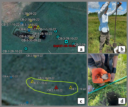
Fig. 5. Drilling sites for the search for the Palaeolithic cultural layer: a, c) plans for the location of drilling wells (sites with artifacts are marked with a triangle); b) exploratory drilling with an auger; d) Palaeolithic artifact from the core.
5 pav. Žvalgymas gręžiniais ieškant paleolito kultūrinio sluoksnio: a, c) gręžinių vietų planai (gręžiniai su artefaktais pažymėti trikampiu); b) žvalgomasis sraigtinis gręžimas; d) paleolito artefaktas iš kerno.
According to the drilling results in Medzhybizh Castle, it was determined that the base of the natural relief of the Castle was a cape-shaped hill. After the 18th century, when the yard level was raised and levelled with backfill, a new scheme of anthropogenic deposits was formed. In the central part of the Castle, the thickness of the cultural layer was 1.5–2 meters. Mostly, a cultural layer of the yard was 2–3 meters. Near the walls in the Western part of the Castle, the cultural layer increases to 3–5 meters, whereas, in the Eastern part of the castle, it reaches as much as 8–11 meters. Based on the drilling data, a series of reconstructions of the courtyard level in the Castle was carried out for different age periods (Fig. 6). The dynamics of changes in the level of the courtyard in correlation with the water collection and drainage systems from the surface of the castle courtyard are traced.

Fig. 6. Reconstruction of the courtyard level in the Eastern sector of the Castle for the 14th–15th centuries based on drilling data.
6 pav. Pilies XIV–XV a. kiemo rytinės dalies rekonstrukcija pagal gręžinių duomenis.
According to the study results of Bar Castle, a non-dissected cultural layer of the 16th and 19th centuries was linked to the relief. The cultural layer and the specifics of filling natural relief depressions to level the area of the yard during the existence of the Castle were fixed. Such exploratory drilling made it possible to qualitatively plan excavations and test pits for the parameters of the area and the depth of the research. Unfortunately, since 2020, research has received no more funding. At the same time, Bar Castle was an example of a combination of the local initiative to revive the Castle and the scientific planning of its archaeological and architectural research.
Exploratory drilling to search for Palaeolithic sites. Positive results of exploratory drilling were obtained at the first stage of work, which took place in the East of Ukraine. Improvement of the drilling equipment and technology, simplification of the extraction of artifacts from cores, optimization of logistics and exploration planning were the goals for the next stage of work. Since 2020, we have been working on the modernization of manual drilling equipment and soil samplers by testing them. Thus, test drilling was carried out on the right bank of the Southern Bug. During this activity, 48 bore wells were made. The soil of the cores was taken completely and washed for the presence of a solid fraction, among which, Palaeolithic artifacts were likely to be found. Also, during the works, an alternative decision was made to process the cores. The solid fraction began to be separated by sieving the cores directly in the field while drilling. A control wash of the sieved soil showed 100% removal of the solid fraction during sieving. In addition, the sieving operation took almost three times less time than washing the cores.
During work on areas with a high level of groundwater, it was found necessary to have both an auger and a core drill at the same time. In drier areas, the core drill gave better time output during drilling. However, with an increase in soil moisture (in areas of swamps, streams, and river beds), it is only possible to work with an auger. Therefore, a set with replaceable drill bits was assembled.
In the course of our experiments, a universal algorithm for exploratory drilling was developed, while taking into account the available equipment and the local soil types. During the development of the exploration algorithm, it was clear that one of the main factors in the limited use of drilling operations is the need to involve professional drillers or geologists. We set a goal to develop not only the equipment but also the method of its use. In such a way, the work could be performed by non-specialists. The entire complex of works was planned to be performed by workers who did not have drilling experience and skills.
To test the new method of exploratory drilling, researchers of the State Historical and Cultural Reserve “Mezhybizh”, who not only had no experience in exploratory or drilling work but also had no experience in archaeological exploration in general, either, were involved. The drilling process was carried out by using the following algorithm: the supervisor of the works gave the points for laying bore wells in the area. The workers were divided into groups of two. Thus, every two experiment participants drilled one bore well and simultaneously sifted the cores (Fig. 7). For example, ceramics restorer I. Kostenko drilled with a hand drill and laid out cores. Researcher T. Vietrova took a photo of the cores and immediately sifted them, selecting the solid fraction. After that, the employees made a panoramic photo of the bore well with a serial number, and covered the top of the bore well with the help of a marked brick. The group leader recorded the GPS coordinates, filled out the borehole passport, and described the cores. After that, the group moved to another place with all the equipment. It took 20–30 minutes to drill one bore well with a depth of 1.0-2.0 m and process the cores. As a result of the work, Palaeolithic artifacts were found in sodden soils. Lifting material on the surface in the area of test drilling was completely absent. The number of artifacts and the nature of their location indicate that not only large residential sites but also small ones can be found in this way.

Fig. 7. Experimental drilling (exploration of the Palaeolithic): a) drilling with a core drill; b) core preparation for screening; c) extraction of 0.5–1.0 cm flint processing micro fragments from the cores.
7 pav. Bandomasis gręžimas (paleolito laikotarpio tyrinėjimai): a) gręžimo procesas; b) kerno paruošimas patikrinimui; c) kerne surastos 0,5–1,0 cm dydžio titnago mikronuoskalos.
The experience of using students interns in similar jobs was also successful. A group of six first-year students with no experience in fieldwork was tasked to lay 15 test bore wells in a meadow and swamp area (Fig. 8a).
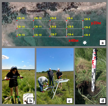
Fig. 8. Drilling practice of first year students: a) drilling well location plan; b) well drilling; c) request cores; d) example of drilling in a swamp (the drilling well is filled with water during drilling).
8 pav. I kurso studentų gręžimo praktika: a) gręžinių vietų planas; b) gręžimas; c) gręžinio kerno tyrimas; d) gręžimo pelkėje pavyzdys (gręžinį apsemia vanduo).
The area of the drilling site was 6,400 m2 (0.64 ha). The planned depth of the bore wells was up to 1.5 m. The total weight of the equipment carried by two students working together was 20–30 kg. Thus, each pair of drillers was self-contained and did not require assistance or vehicles. It took about three hours to complete the task of laying 15 bore wells (instruction, conducting work, recording results). Undoubtedly, detailed excavation of such an area of heavy wet soils by a group of students without previous experience in fieldwork would not have given such results. It deserves attention that 100% of artifacts are removed while drilling with soil screening. That is why the leader of the reconnaissance group can involve workers without fieldwork experience. Error and loss of artifacts from the cores (when adopting this technique) is simply impossible.
Summarizing the results of exploratory drilling experiments to find Palaeolithic monuments, the following can be noted: we have developed practical experience of drilling with a hand drill with core and auger nozzles. It should be pointed out that there is virtually no difference in the operation of these nozzles on light, loamy soils. However, since an intact core is required for soil science analysis, a column nozzle should be used. There are some features of using these nozzles in search of artifacts. The distance between the spiral branches of the auger is 3-4 cm. Due to this, an artifact will be pushed by the auger towards the bore well and may fail to get to the core. When using a drill cup, the size of artifacts that can be removed by it is determined by the diameter of the cup (in our case, it is 70–100 mm). Such limitations of drilling equipment must be taken into account while conducting exploratory drilling to obtain artifacts.
Exploratory drilling with a hand tool was used in our work during excavations in Medzhybizh Castle (Fig. 8c). It was mainly carried out to obtain preliminary information on the structure below the underlying cultural layer. During reconnaissance work in the territory of the medieval town of Medzhybizh, preliminary drilling gives an idea of the state of the cultural layer and dating. Micro fragments of ceramics, in this case, are sufficiently informative material, and, in most cases, these fragments do not require additional verification by digging the cultural layer.
On the grounds of the results of the experiments, it is possible to determine that the effect of using drilling methods in archaeological practice is achieved by using a different range of drilling methods in one team. The main deep wells are the foundation of the qualitative research implemented on a massive object (castle, town) and serve as the geological basis of regional archaeological research.
In the search for archaeological monuments, we recommend the optimal depths of exploratory drilling, which is from 1 to 2 meters. Such depths can be reached with simple drilling equipment. In addition, we note that the depths of most exploratory shafts during mass scientific explorations or when investigating new construction sites are the same, from 1 to 2 meters. The maximum effect of such works will be achieved on turfed areas of river terraces, lake shores, peat bogs, dunes or turfed sandy locations in a forest. It is also possible to recommend exploratory drilling on agricultural land, where point drilling will not cause damage to cultivated areas and raise the question of compensation for the consequences of archaeological exploration.
The simple drilling technology during exploration works allows thе use of un(der)qualified personnel. It is possible to conduct exploratory drilling in the course of the archaeological practice of first-year university students. The algorithm of using a manual drill is simple, and the technique of sifting cores is unambiguous and error-free. As a result, this makes it possible to involve a wide range of students and volunteers of any age, gender, and qualification in the work. This type of exploratory drilling is fundamentally different from drilling exploration. Every archaeologist who has planned explorations involving excavation knows that only an employee with field experience can be instructed to lay an excavation. Otherwise, the loss of archaeological material during unqualified excavation is inevitable. The limited number of qualified personnel often limits the amount of excavation in scientific explorations or in explorations in areas of new buildings. These problems are eliminated by using this exploratory drilling method. Thus, drilling during archaeological exploration can be used as an alternative to test pits.
References
Colarossi, D., Fewlass, H., Stahlschmidt, MC., Presnyakova, D., Matembo, J., 2022. A targeted drilling and dating campaign to identify Stone Age archaeological sites before excavation in west coast southern Africa. Quaternary Geochronology, 71, e101314. https://doi.org/10.1016/j.quageo.2022.101314
Instytut Archeologii i Etnologii Polskiej Akademii Nauk, 2017. Exploitation and processing of chocolate flint during Paleolithic and Mesolithic in the North-Western part of its deposits based on non-invasive archeological and geophysical research and test-trenches. [online]. Available at: http://iaepan.edu.pl/exploitation-and-processing-of-chocolate-flint-during-paleolithic-and-mesolithic-in-the-north-western-part-of-its-deposits-based-on-non-invasive-archeological-and-geophysical-research-and-test-trenche/ [Accessed 12 june 2023].
Kadurin, S., Yanko-Hombach, V., Smyntyna, O., 2020. The Ukraine: In search of submerged Late Palaeolithic sites on the north-western Black Sea shelf. In: Bailey, G., Galanidou, N., Peeters, H., Jöns, H., Mennenga, M. (eds.). The Archaeology of Europe’s Drowned Landscapes. Coastal Research Library, 35. Cham: Springer, p. 413-428. https://doi.org/10.1007/978-3-030-37367-2
Nebraska Archaeology, 2020. Archeology on the Lincoln South Beltway. [online]. Available at: https://nebraskaarchaeology.org/tag/soil-core/ [Accessed 03 june 2023].
Vengalis, R., Piličiauskas, G., Minkevičius, K., Valančius, M., Stančikaitė, M., Vaikutienė, G., Piličiauskienė, G., 2022. New data on the structure and economy of unenclosed settlements in the Late Striated Ware Culture: the Skudeniai settlement site in southeastern Lithuania. Lietuvos archeologija, 48, 101-153.
Vengalis, R., Volungevičius, J., Vėlius, G., Kuncevičius, A., Poškienė, J., Prapiestienė, R., 2020. Žmogus prieš gamtą: reljefo transformavimas įrengiant XIII–XIV a. Kernavės pilį ir jo sukelti eroziniai procesai. (Man Against Nature: the Transformation of the Relief During the Construction of Kernavė Castle in the 13th–14th Centuries and the Erosional Processes it Created). Lietuvos archeologija, 46, 207–253.
Vetrov, V., 2015. Preliminary Study of Lugansk Paleolithic Micro-region of the East of Ukraine. The Sheffield Graduate Journal of Archaeology, [online] 14, 1-11. Available at: https://assemblagejournal.files.wordpress.com/2015/12/vetrov-2015.pdf [Accessed 22 June 2024].
Wessex Archaeology, 2017. Borehole Drilling Survey [online]. Available at: https://www.wessexarch.co.uk/archaeological-services/borehole-drilling-survey [Accessed 12 june 2023]
Ветров, В.С., Кармазиненко, С. П., Маничев, В.И., 2013. Предварительное комплексное геоархеологическое исследование Луганского палеолитического микрорегиона. В: Бердников, И. М., Липнина, Е. А. (ред.). Евразия в кайнозое. Стратиграфия, палеоэкология, культуры. Материалы 2-й Всеросийской научной конференции: Фундаментальные проблемы формирования разнообразия палеосреды и палеокультур Евразии. Смена парадигм, 2. Иркутск, Россия, 22 апреля 2013 г. Иркутск: Издательство ИГУ, с. 51-59.
Вєтров, В.С., Степанчук, В.М., Веклич, Ю.М., Погорілець, О.Г., Науменко, О.О., 2021. Звіт про розвідки місцезнаходжень нижнього палеоліту на території Летичівського району Хмельницької області в 2021 р. Меджибож, 2021.
Гарник, В.Ф., Віславський, В.Т., 2016. Робочий проект реставрації мосту з брамою (складова частина мурів з баштою, XVI ст.) в смт. Меджибіж, Летичівського району Хмельницької області. Шифр 416/16. Технічний звіт з інженерно-геологічних вишукувань. Укладач В.Ф. Гарник, В.Т. Віславський. Хмельницький.
Жадан, П.П., Ращенко, А.М., 2017. Реставрація об’єкту: «Палац замку XIV-XVI ст. в смт. Меджибіж Летичівського району Хмельницької області». Інженерно-геологічні вишукування. Технічний звіт з інженерно-геологічних вишукувань на майданчику реставрації. /15-В. Том 2.6. Укладач П.П. Жадан, А.М. Ращенко, переглянуто 26 травня 2017.
Завгородний, А. Н., Коваленко, А. Г., 1965. Отчет о результатах геологической съемки масштаба 1:50000 в Суходольском геологическом районе Донецкого бассейна. Т. 2. Гомгеолком УССР, трест «Луганскгеология» Луганская комплексная геологическая экспедиция, Геоинформ, № 25782.
Пламеницька, О., 2002. Барський замок. Військово-історичний альманах, № 2 (5), 100-107.
Пустовєтов, І.А., 2019. Інженерно-геологічні вишукування. Технічний звіт (вул. Шевченко, 4 в смт Меджибіж Летичівського району Хмельницької області). АРХ № 0418-2019-В. Укладач І.А. Пустовєтов.
Толкачов, Ю., 2010. Меджибізький замок. Київ, ФОП Поліщук О. В.
Язвінський, О.В., Олійник, Г.А., 2021. Інженерно-геологічні вишукування для проекту реконструкції Барського замку за адресою: вул.. Буняковського, 7 м. Бар, Вінніцька область. Технічний звіт за результатами інженерно-геологічних вишукувань 19.07.20. Укладач: О.В. Язвінський, Г.А. Олійник. Київ.
Viktor Vietrov
Summary
This study focuses on the effectiveness of drilling methods in archaeological research. As an example of stationary research, we took two large objects — Medzhybizh and Bar castles in the West of Ukraine. The objects of field explorations are Palaeolithic sites that we engaged using drilling methods in the East and West of Ukraine.
Architectural restoration and archaeological research in Medzhybizh Castle, which already spans over more than 50 years, has revealed the stages of the Castle’s development from the 12th to the 19th century. However, the detailed stratigraphy of the monument was not known. Excavations explored the cultural layer to a depth of up to 3 meters. We laid test pits up to 6 meters deep. Yet, this did not always reveal the entire cultural layer. Only detailed drilling in the courtyard, behind the Castle’s walls and inside its premises, made it possible to determine the thickness of the cultural layer in parts of the Castle as reaching a level of 8–11 meters. Work was carried out at depths of up to 20 meters using manual and mechanized drilling equipment. Thanks to the drilling, we had the opportunity to properly plan the archaeological work and clear the premises to a depth of 11 meters.
The preparation of architectural and restoration works in Bar Castle immediately showed the ineffectiveness and high cost of archaeological excavations (especially at depths of more than 4–6 meters). Thanks to exploratory drilling, we developed a general understanding of the thickness and structure of the cultural layer within the Castle’s territory very quickly and with minimal financial costs. Work was carried out at depths of up to 12 meters by using manual drilling equipment. Thus, it helped to plan the necessary archaeological work appropriately.
Field explorations of Palaeolithic sites by employing drilling methods have shown their effectiveness in the East and West of Ukraine. We found out that drilling to a depth of 1–3 meters makes it possible to obtain data on the stratigraphy and artifacts from cores with significantly lower labor costs than test pits. Thus, a small team could cover a considerable area with the help of bore wells. The developed technique allows the usage of un(der)qualified personnel (students, volunteers) in archaeological drilling without compromising the quality of work. The effectiveness of exploratory drilling under extreme conditions (swamps, heavy soils) was noted. A combination of the rapid speed of work, the high quality of extracting artifacts from the core and the non-invasiveness of the drilling methods on archaeological sites make them promising for use in reconnaissance, security, and architectural restoration work.
Viktor Vietrov
Santrauka
Straipsnis skirtas gręžimo metodų veiksmingumui archeologiniuose tyrimuose aptarti. Kaip stacionarių tyrimų pavyzdžiai pristatomi du dideli objektai – Medžybižo ir Baro pilys Ukrainos vakaruose. Archeologiniai žvalgymai atlikti gręžimo metodu ieškant paleolito objektų Ukrainos rytuose ir vakaruose.
Daugiau nei 50 metų trukusi Medžybižo pilies architektūrinė restauracija ir archeologiniai tyrimai nustatė pilies raidos etapus nuo XII iki XIX amžiaus. Tačiau detali šio objekto stratigrafija nebuvo atskleista. Kasinėjimų metu kultūrinis sluoksnis ištirtas iki 3 metrų gylio, archeologiniai šurfai iškasti iki 6 metrų gylio. Tačiau tiriant tokiu būdu kultūrinį sluoksnį ne visada pavykdavo visiškai įvertinti. Tik gręžimas kieme, už pilies sienų, ir pilies patalpų viduje leido nustatyti kultūrinio sluoksnio storį, kuris kai kur siekė iki 8–11 metrų. Gręžimo darbai buvo vykdyti iki 20 metrų gylio, naudojant rankinio ir mechanizuoto gręžimo įrangą. Gręžimo metodų taikymas sudarė sąlygas tinkamai suplanuoti archeologinius darbus ir išvalyti atitinkamą teritoriją iki 11 metrų gylio.
Rengiantis architektūros ir restauravimo darbams Baro pilyje iš karto paaiškėjo, kad archeologiniai kasinėjimai (ypač didesniame nei 4–6 metrų gylyje) yra neefektyvūs ir brangūs. Išgręžus žvalgomuosius gręžinius labai greitai ir su minimaliomis finansinėmis sąnaudomis pilies teritorijoje nustatytas kultūrinio sluoksnio storis ir struktūros. Darbai buvo atliekami iki 12 metrų gylio naudojant rankinio gręžimo įrangą. Tai padėjo kokybiškai suplanuoti būtinus archeologinius tyrimus.
Paleolito radaviečių archeologiniai žvalgymai Ukrainos rytuose ir vakaruose įrodė gręžimo metodų efektyvumą. Nustatyta, kad gręžiant 1–3 m gyliu galima gauti duomenų apie objekto stratigrafiją ir surinkti artefaktus iš kerno, o darbo sąnaudos yra gerokai mažesnės nei kasant archeologinius šurfus. Taigi nedidelė komanda gręžiniais gali aprėpti nemažą plotą. Metodas leidžia gręžiniams naudoti nekvalifikuotus darbuotojus (studentus, savanorius) ir dėl to nenukenčia archeologinių tyrimų kokybė. Nustatyta, kad žvalgymai atliekant gręžinius yra efektyvūs ekstremaliomis sąlygomis (pelkėse, sunkiuose dirvožemiuose). Darbo sparta, artefaktų išgavimo iš kerno kokybė, taip pat nedestruktyvumas archeologinėse vietovėse – šių savybių derinys sąlygoja, kad gręžimo metodai yra perspektyvūs atliekant archeologinius žvalgymus, saugojimo ir architektūros restauravimo darbus.