Archaeologia Lituana ISSN 1392-6748 eISSN 2538-8738
2024, vol. 25, pp. 221–241 DOI: https://doi.org/10.15388/ArchLit.2024.25.9
Viktor Vietrov
State Historical and Cultural Reserve “Mezhybizh”
Medzhybizh, Ukraine
vetrov.poryad@gmail.com
ORCID ID https://orcid.org/0000-0001-6948-7599
Kseniia M. Bondar
Institute of Geophysics, Polish Academy of Sciences
Ksiecia Janusza 64, 01-452 Warsaw, Poland
Taras Shevchenko National University of Kyiv
Vasylkivska 90, 03022 Kyiv, Ukraine
kbondar@igf.edu.pl
ORCID ID https://orcid.org/0000-0002-4946-7707
Abstract. We present the results of recent geophysical and archaeological investigations conducted in Medzhybizh Castle located in Western Ukraine. Architectural and restoration studies extending over more than half a century have revealed that part of the castle was built during the Lithuanian period, i.e., in the 14th–15th centuries. Our study is focused on ground penetrating radar (GPR) surveys investigating the courtyards of the castle including the Lithuanian part, and inside the buildings. The GPR survey was capable of detecting elements of the ancient architecture under a horizon of debris and soil up to 3 m deep. Possible structures of a Lithuanian castle have been suggested and confirmed by recent archaeological excavations. These are fragments of the Western Wall, a stone construction stretching along the façade of the Southern Building, and a fundament ditch of the inner wall in the Southern Building.
Keywords: ground penetrating radar, Medzhybizh, Lithuanian castle.
Anotacija. Straipsnyje pristatomi naujausi geofizikiniai ir archeologiniai tyrimai, atlikti Vakarų Ukrainoje esančioje Medžybižo pilyje. Daugiau nei 50 metų trukę architektūriniai tyrimai ir restauravimo darbai atskleidė šios pilies lietuviškąjį laikotarpį, datuojamą XIV–XV a. Tyrimai naudojant georadarą (GPR) buvo atlikti pilies kieme ir pilies pastatų viduje. Tyrimo georadaru metu buvo galima fiksuoti senuosius architektūros elementus, dabar esančius po nuolaužų ir dirvožemio sluoksniu, kuris siekia net iki 3 m storio. Galimos Medžybižo lietuviškosios pilies struktūros buvo nustatytos ir naujausių archeologinių tyrimų metu. Tai – pilies vakarinės sienos fragmentai, ties pietinio korpuso fasadu besidriekianti akmeninė konstrukcija, pietinio korpuso vidinės sienos pamatų griovys.
Reikšminiai žodžiai: georadaras, Medžybižas, lietuviškoji pilis.
__________
Acknowledgements. We thank our Lithuanian colleagues Linas Kvizikevičius and Gintaras Džiovėnas for their valuable consultation during our work.
Geophysical work was undertaken with support provided by the International Society for Archaeological Prospection, through the ISAP Fund grant scheme.
Received: 07/09/2024. Accepted: 04/12/2024
Copyright © 2024 Viktor Vietrov, Kseniia M. Bondar. Published by Vilnius University Press. This is an Open Access article distributed under the terms of the Creative Commons Attribution License, which permits unrestricted use, distribution, and reproduction in any medium, provided the original author and source are credited.
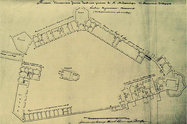
Medzhybizh Castle (N 49°26′19″; E 27°24′10″) is located on the Northern bank of the Pivdennyi Buh (the Southern Bug) River at the confluence with its Northern tributary, the Buzhok River, in the Eastern part of Khmelnytskyi Region. The first wooden and earthen fortifications were erected here in the second half of the 11th century. The stone fortification of the Castle appeared in the second half of the 14th century. By the middle of the 17th century, the Castle was modernized, whereas, from the 18th century onwards, the Castle lost its military significance. The use of the Castle within the period spanning from the 18th to the 20th centuries only involved economic purposes. It was associated with numerous architectural and landscape changes. Currently, the Castle looks like an elongated pentagon measuring 167×85 meters. The Castle has stone walls around the perimeter, five towers of different types, two palace buildings, a church, a bridge, and outbuildings (Fig. 1).
Fig. 1. Plan of Medzhybizh Castle, 19th century. Retrieved from the Album of Archival Materials on the Architectural Monument of the 13th–19th Centuries. Kyiv, 1970, p. 6.
1 pav. Medžybižo pilies planas, XIX a. Paimta iš archyvinės medžiagos albumo, skirto XIII–XIX a. architektūros paminklams. Kyjivas, 1970, p. 6.
In the second half of the 14th century, the part of Podillia, where the Medzhybizh Castle is located, was handed over by the Grand Duke of Lithuania Olgierd to the management of the Koriatovych (Karijotas) princes. They were modernizing the existing fortifications in Podillia and building new castles as well. Thus, a small stone castle arose based on the earthen fortifications of the three-shaft Russian settlement of Mezhybizh (Ponomarova, 1971, 2). As a result of numerous reconstructions and a significant increase in the level of the courtyard, the fortification of the Lithuanian Castle in Medzhybizh was buried under several meters of soil layering. Mainly, the modern archaeological research is aimed at finding the buildings and restoring the structures from that time.
This paper is devoted to the results of the ground penetrating radar (GPR) surveys and archaeological excavations guided by geophysical findings in the Medzhybizh Fortress. Our study is focused on the Lithuanian Castle elements, however, GPR investigations are needed in the context of renovation works in the courtyard of Medzhybizh Castle as well as for planning drainage systems, landscaping the territory, and laying communication networks.
Geophysical studies play an important role in the examination and preservation of archaeological sites, churches, castles, and other objects of cultural heritage. GPR surveys in castles mainly have a goal to determine promising locations for future archaeological excavations. In order to adapt the GPR methodology to the specific conditions and tasks of Medzhybizh Fortress, we have analyzed the European experience. In Corvin Castle (Romania), GPR scanning was carried out in the depth range of 0.25–0.95 m to identify the foundations of its outbuildings of the 17th century without subsequent archaeological confirmation of the discovered objects (Morris et al., 2022). In Shrewsbury Castle (England), ground-penetrating radar scanning was conducted to identify objects in the drainage system. Scanning was carried out in the designated areas before archaeological research. Test excavations took place at depths of 1–1.5 m. In general, the GPR data related to the natural topography of the yard were confirmed, the presence of natural depressions and artificial trenches was attested, and communication with the well was found (Baker 2020). In the castle of Pancorbo (Spain), electrical resistance tomography was used in addition to GPR imaging. At the same time, anomalies from the foundations of dwellings that were found by subsequent excavations were discovered in the course of the GPR survey (Fernández-Álvarez et al., 2017). It is also of interest to overview the experience of GPR shooting in a large square in the old city center of Augusta (Italy). The probing depth of the soil stratum reached 3 m. Anomalies, which were interpreted as ancient foundations of buildings and underground communications, were discovered based on previous archaeological data on the layout of the medieval city. Verification of geophysical information by archaeological excavations was not carried out (Cacciaguerra et al., 2022).
When facing the objective of presenting a multifaceted study of Medzhibyzh Castle, we relied on the architectural concept of its development. Field research of the Lithuanian core of the Castle was carried out by using archaeological methods. GPR surveying was used in our work in the context of archaeological works. In this way, GPR surveying served as the basis for planning the volumes and areas of archaeological research. At the same time, the information of the GPR survey was carefully checked by excavation and trenching of possible objects. Thus, we achieved a high level of correlation of ground-penetrating radar survey data with the results of archaeological research of the entire object in the complex.
The concept of the development of the Lithuanian Castle was elaborated by the architect and restorer Yevheniia Lopushynska. The main points of the concept were developed in the works of archaeologists A. Avagyan, Yu. Tolkachov, O. Pogorilets, and S. Stopenchuk (Толкачов, 2010).
During the 14th–15th centuries, the Castle had the shape of an equilateral triangle with sides 60 meters long (Fig. 2). Two construction stages can be identified in the Castle. The first stage probably dates back to the very end of the 14th century, whereas the second stage can probably be referred to the initial decades of the 15th century. The first stage is related to the construction of basic fortification: walls around the perimeter of the Castle, the Towers, and the Barbican. In the second stage, palace buildings appear, one of which is attached from the inside to the Southern Wall (Southern Building), whereas the second palace building is attached from the outside to the Eastern Wall. Thus, in the first half of the 15th century, the castle had two residential buildings of the defense-palace type. Over time, these buildings became the foundations of the Sieniawski-Czartoryski Palace (16th–17th centuries) and the ‘Hetman’s Chambers’ (the Eastern Palace of the 16th–17th centuries). In the 14th century, there were several entrance gates to the Castle. The first entrance was from the West through a system of ditches under the protection of a small semicircular tower. Another one was from the East, under the defense of the Barbican, through a round gate tower.
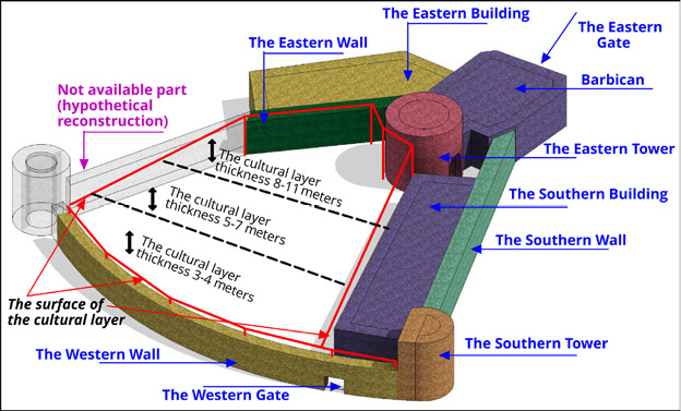
Fig. 2. 3D sketch of the Lithuanian Castle (14th–15th centuries). Thickness of soil filling in different parts of the Lithuanian Castle (reconstruction by V. Vietrov, N. Nizhnik).
2 pav. Medžybižo lietuviškosios pilies 3D modelis (XIV–XV a.). Nurodytas kultūrinio sluoksnio storis įvairiose lietuviškosios pilies vietose (V. Vietrovo, N. Nižniko rekonstrukcija).
During the 16th and 17th centuries, when the Polish-Lithuanian Commonwealth was in power, the Castle expanded its territory to the West (Fig. 11). It is squeezed from two sides by rivers in a limited area, which makes significant modernization impossible. Therefore, the modernization of the fortifications was implemented by raising the level of the outer walls. At the same time, the Barbican of the 14th–15th centuries was covered by a three-tiered tower (similar to a bastion).
At the beginning of the 18th century, the castle was no longer used as a defense structure. Therefore, for the improvement of the territory, the moat, and part of the fortification walls of the Lithuanian period were not dismantled, but filled with soil instead. After raising (filling) the level of the castle yard in the 18th century, those tiers of buildings that were built in the late 14th – early 15th centuries went underground, to different depths.
Thus, the core of the Castle of the Lithuanian period was preserved in the Eastern part of the castle of the 16th–18th centuries. In the 19th century, the lower levels of both palaces, all the towers of the Lithuanian time and the Barbican were filled with soil. This saved the buildings of the 14th and 15th centuries from destruction during the Soviet time. In Fig. 2, the thickness of the backfill (from the modern surface to the bottom of the Lithuanian Castle buildings) is represented. It is 3–4 meters in the Western part of the Castle, 5–7 meters in the central part, and 8–11 meters in the Eastern part. This filling level causes difficulties for the research and archaeological stripping of the structures of the Lithuanian period. The archaeological stripping of the space between the Southern Palace and the Round Tower with partial clearing of the Barbican was carried out to a depth of 8–11 meters and became a serious test of technique and methodology during excavations.
The dating of the architectural and fortification objects of Medzhybizh Castle is based on determining the chronology of the construction stages. The rationale for identifying the stages comprises peculiarities of the architectural style, construction technology (various building materials, mortars), types and forms of the fortification objects. Based on this information, the main architect-restorer of the Castle, E. Lopushynska, developed historical and architectural schemes for the development of the Castle. These schemes were used when planning archaeological research (Лопушинская и др., 1990). Thus, a significant amount of archaeological information in Medzhybizh Castle came from the excavations of the 20th century. Although, at this time, many objects were investigated by test pits and small trenches, the modern use of these results is limited due to insufficient registration of stratigraphy, lack of soil lithology, as well as a small volume and poor quality of photography. Stratigraphy processing is complicated by the absence of absolute elevation marks on architectural and archaeological drawings. All the listed data are sufficient for setting the problems and basic hypotheses, but not for forming final conclusions.
Our research is based on modern archaeological examining dating back to 2017–2023. At the first stage of the research, we ordered a topographic model of the castle. This made it possible to study in detail the heights of previous excavations, to select small landforms, and to convert the available data into one system of absolute heights.
The next stage was soil research with the objective to find out the depth of the cultural layer in different parts of the Castle. Also, this made it possible to obtain data on the technical composition of the soils of the cultural layer and its natural basis, the level of soil moisture, and the presence of aquifers. With this purpose, a series of wells were drilled. The wells were made by different types of drilling, depending on the required type of the core and the depth of the well. The geological information on a portion of the wells was duplicated by test pits, from which, detailed stratigraphic information was obtained (Fig. 3). At the same time, wells were drilled in some stratigraphic pits with a hand drill in order to obtain additional information about the geology below the cultural layer at levels from 2 to 8 meters.
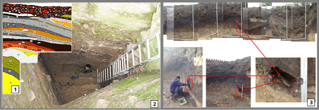
Fig. 3. Sections 3.1 and 3:2. Excavation outside the wall of the Lithuanian Castle (test pit 5, 2018, depth 6.2 m). Section 3.3. Chronological marking of stratigraphy profiles (2022) (photo by V. Vietrov).
3 pav. 1, 2 – tyrimai už Medžybižo lietuviškosios pilies sienos (5 šurfas, 2018 m., gylis 6,2 m). 3 – stratigrafinių profilių chronologiniai žymikliai (2022 m.) (V. Vietrovo nuotr.).
In addition, we realized that, in medieval castles, the stratigraphy of adjacent areas can differ significantly due to the local presence of domestic buildings, earthen fortifications, burials, and other objects that may have disrupted the stratigraphy. Therefore, in 2021, taking advantage of the earthwork on the area of the Southern Wall, we laid two stratigraphic profiles with a length of 18 m, a width and a depth of 3 m (Fig. 11). The profiles were located parallel to each other at a distance of 10 meters. In 2021–2022, comprehensive processing of 120 m2 of stratigraphic profiles was carried out with clear dating of layers based on typologically significant material and with the use of soil science analyses. A stratigraphic column was composed reflecting the historical periods of the Castle’s timeline. On the basis of these works, an unsegmented horizon of the 12th–15th centuries was identified. Its upper part (or its surface) became a stratigraphic marker for processing the Lithuanian Castle zone (Fig. 3.3).
Artifacts from our excavations sufficiently outline the period of the 14th–15th centuries. In the unsegmented layer of the 12th–15th centuries, there are artifacts that, in our opinion, are directly related to the life of the Lithuanian Сastle. Gothic tiles are presented in the ceramic complex. The tiles have a square face brush measuring about 12×12 cm. The surface is decorated with geometric ornaments of squares, crosses, and semicircles. The shield can be completely closed (Fig. 4.1) or slotted (Fig. 4.2), when part of the decorative elements is manually cut along the contour. Lattice tiles are also available (Fig. 4.3). The rump can be long closed or short opened at the back. The sacrum can be long and closed or short and open at the back. Similar tiles are present in the 15th-century complexes in Western Ukraine (Кахлі Волині XV–XVIII ст., 2018, 7).
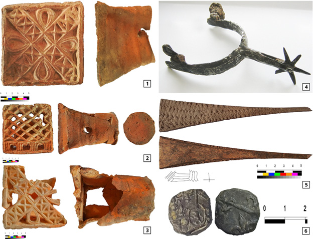
Fig. 4. Section 4.1. Gothic tile of the 15th century. Excavation, 2017. Section 4.2. Gothic slotted tile of the 15th century. Excavation, 2017. Section 4.3. Gothic lattice tile of the 15th century. Excavation, 2017. Section 4.4. A bone stylus with a graphic drawing on the back. 15th century. Excavation, 2017. Section 4.5. The spur was found near the Western Wall of the Southern Building. 14th–15th centuries. Excavation, 2017. Section 4.6. Lead seal. Found near the façade of the South Building. Excavation of 2020. Comparison of image elements with the coat of arms of Philip III the Good, Duke of Burgundy (photo by V. Vietrov).
4 pav. 1 – XV a. gotikinis koklis. 2017 m. tyrimai. 2 – XV a. gotikinis puodyninis koklis su ažūrine plokšte. 2017 m. tyrimai. 3 – gotikinis XV a. koklis. 2017 m. tyrimai. 4 – kaulinis stilius su grafiniu piešiniu. XV a. 2017 m. tyrimai. 5 – pentinas, surastas prie pietinio pastato vakarinės sienos. XIV–XV a. 2017 m. tyrimai. 6 – švininė plomba, surasta prie pietinio korpuso fasado. 2020 m. tyrimai. Plombos paviršiuje įspausti ženklai lyginami su Burgundijos kunigaikščio Pilypo III Gerojo herbu (V. Vietrovo nuotr.).
In 2017, two bone styluses were found in the perimeter of the Lithuanian Castle. The stylus, shown in Fig. 4.5 is analogous to the stylus that was found during the excavations of the Radziwiłł Palace in Dubingiai Castle (Kuncevičius, Laužikas, 2012, 237). The stylus from the excavations of Dubingiai Castle dates back to the 15th century. The category of military ammunition is mainly represented by materials with a wide dating. The arrowheads that have been found are placed in a wider time period of the 13th–15th centuries. Buckles and metal ends of belts are periodized in the same way. At the same time, certain elements of the equipment, such as spurs (Fig. 4.4), have a sufficiently substantiated dating to the 14th century based on analogies of the local monuments (Peskova, 2020, 98–101). Another category of artifacts, which is directly related to the Lithuanian Castle in terms of its location, is crossbow bolts. The first series of crossbow bolts (10 pieces) was discovered in 2009–2015, during excavations near the Western Wall of the Lithuanian Castle (Толкачов, Купрій, 2021, 129, Figs. 1, 2).
During the excavation campaign of 2017–2018, 24 crossbow bolts were found in the area of the Western Gate of the Lithuanian Castle. At this time, more than 100 crossbow bolts were found at the Western Gate in an area of 20×20 meters. The stratigraphy of this area is represented by mixed soils with numerous small fragments of burned wooden structures, burnt soil, as well as human skulls without skeletons. It should be noted that there are no finds of crossbow bolts on the entire remaining area of Medzhybizh Castle, except for the burial site, which was unearthed on the outer side of the Lithuanian Castle. According to Tolkachev and Stopenchuk, the timeframe of crossbow use in Medzhybizh ranges from the second half of the 14th century to the middle of the 15th century (Толкачов, Купрій, 2021, 128–133; Стопенчук, 2021, 153–161).
To the period of existence of the Lithuanian castle, the lead seal (see Fig. 4.6), which was found near the façade of the Southern Building can be attributed (it is a find of the excavation of 2020). On one side of the seal, in the center of the field of the shield, there is a profile of a lion standing on its hind legs (1), and the space around the shield is divided by lines into four (?) sectors. Lilies (2) are depicted in the upper left sector. In the upper right sector, there are two lines which are slanted from left to right (3). In the lower left sector, there is a vertically elongated silhouette (of an animal (?)). The lower right sector did not enter the field of the lead blank due to a displacement of the die. On the reverse side of the seal, there are images of lilies and a line sloping from left to right. The comparison makes it possible to believe that the image on the seal corresponds to the design of the coat of arms of Philip III, Duke of Burgundy (1396–1467).
It is difficult to identify the mass ceramic material of the 14th and 15th centuries because, with the transition of Podillia towards the control of the Grand Duchy of Lithuania, there was no radical change in the technology of the local pottery. Yet, it is possible to outline its general visible features. These are the change in the angle of deviation of the crown, a reduced thickness of the walls of the pots, and the appearance of mica microparticles in the ceramic mass. However, these changes are not significant, and it is difficult to reliably establish them during the selection of fragments of bulk ceramic material. A substantial change in the traditions of making pottery in Medzhybizh took place after the beginning of the 16th century, which is recorded by reference monuments of that time.
Currently, the area of the excavations and test pits, which in their depth reached the natural loam in the area of the Lithuanian Castle, is not more than 20% of its total area. The most specific data relate to the study area between the modern Sieniawski Palace (on the diagram of the Lithuanian Castle, it is the Southern Building) and the Western Gate in the Western Wall. As excavations were carried out due to the need for urgent and restoration work, they were very short on time and took place, to a large extent, in winter. Essentially, we can outline the general features of stratigraphy and planigraphy of the objects in this area.
In the area of the Western Gate, the stratigraphy is represented by mixed clayey soils of the black and dark grey color. Fragments of burnt wood, ceramics, and layers of charcoal are present in the soil. There are widespread patches of scorched soil. Extensive work of horizontal archaeological stripping of areas with burnt soil (Fig. 5.1) and stripping off their surface (Fig. 5.3) was carried out. The irregularity of the vertical arrangement of the burned areas indicates that they were displaced, that is, bulk. At the same time, the presence of fragile artifacts (for example, fragments of mesh tiles, or remains of thin burnt wooden structures) in the overfilled soil (Fig. 5.2) indicates that the soil was moved once. It is also obvious that the soil for backfilling was taken from a nearby location. It comes from the area of outdated earthen fortifications of the 14th and 15th centuries, which were probably dismantled. Also, part of the soil could be removed from the foundation pit of the rectangular tower, built in the 16th century on the Southwestern corner of the Lithuanian Castle. In our opinion, the spots of scorched soil are related to the fire that accompanied the storming of the Western Gate of the Lithuanian Castle. The possibility of such events is indicated by the extraordinary concentration of crossbow bolts (Fig. 5.4), which is many times higher than their concentration in other excavations of Medzhybizh Castle. However, it should be noted that, in the area of the Western Gate, as in other excavations, we cannot yet stratigraphically distinguish the day surface of the 14th–15th centuries. Hence, we are dealing with an undivided stratigraphic horizon of the 12th–15th centuries, whereas the objects must be investigated individually, while taking into account the general concept of the periodicity of the development of Medzhybizh Castle.
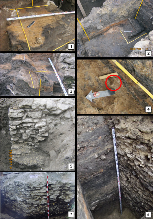
Fig. 5. Section 5.1. Archaeological stripping of the burnt layer (Excavation, 2017). Section 5.2. Fragments of burnt wooden structures (Excavation, 2017). Section 5.3. Archaeological stripping of the surface of burned strata (Excavation, 2017). Section 5.4. Crossbow bolt in a burnt layer (Excavation, 2017). Section 5.5. The Southern end of the Western Wall with the lower platform (Excavation, 2017). Section 5.6. A stone object near the edge of the Western Wall (Excavation, 2017). Section 5.7. Western Wall. Excavation VI, 2000 (photo by V. Vietrov).
5 pav. 1 – archeologinio sluoksnio su gaisro pėdsakais tyrimai (2017 m. tyrimai). 2 – sudegusių medinių konstrukcijų fragmentai (2017 m. tyrimai). 3 – archeologinio sluoksnio su gaisro pėdsakais paviršiaus tyrimai (2017 m. tyrimai). 4 – arbaleto strėlės antgalis degėsių sluoksnyje (2017 m. tyrimai). 5 – vakarinės sienos pietinis galas su pamatų išplatėjimu (2017 m. tyrimai). 6 – akmenų struktūra prie vakarinės sienos (2017 m. tyrimai). 7 – vakarinė siena. VI perkasa, 2000 m. (V. Vietrovo nuotr.).
In the area of the Western Gate, the cultural layer ranges from 2.5 to 3.5 meters. The distance from the daytime surface (with the cobblestones of the 18th–19th centuries) to the top of the undivided horizon of the 12th–15th centuries was about one meter. The height of the Western Wall at the place of the excavation is from 2.0 to 2.5 meters. The wall is built of large blocks of limestone, and held together by limestone mortar. In the central part, the height of the wall is 1.5–2.0 meters (Fig. 5.7), which can be explained by partial dismantling.
At the Southern end, the wall ended with a platform that was 0.5 m wide in the lower part. The probable purpose of the platform is related with the fastening of the gate support or the lattice (Fig. 5.5). It is possible the second part of the gate or lattice fastening was linked to a 3×3×3 meter masonry object which was found in the course of the excavations. It is located three meters South of the Southern end of the wall. The object is built of small limestone blocks stacked on clay mortar. In 2017–2018, we had the opportunity to explore only its top and Eastern edge (Fig. 5.6). Later, its Southern and Northern sides were partially explored (yet not to the bottom of the structure).
In addition to the archaeological stripping the area of the excavation, several stages of tracing the surface of the Western Wall were carried out. These archaeological works confirmed the conformity of its location with the basic architectural scheme of the reconstruction of the Lithuanian Castle.
The planigraphy of other fortification objects of the Lithuanian Castle was studied mainly by internal archaeological stripping of the structures. The disadvantages of this archaeological method were fully justifiable because the significant depth of the backfill (5–8 meters) prevents local excavations. Excavations of a limited area with walls more than three meters high are unacceptable from the point of view of work safety on loose soils. Over the past fifty years, trial excavations have been dug more than once on all the fortifications shown on the Castle diagram to determine the level of foundations, the existence of underground levels, passages, and other architectural details. However, this method of research has left us with numerous problems, including those related to the state of preservation of the underground parts of the buildings. Among other things, the museification of these unique buildings was not the last issue. Therefore, in 2017, the archaeological service of the State Historical and Cultural Reserve Medzhybizh came out with a proposal to carry out a complete clearing of fortification objects from the middle, with total excavation of the soil up to the cut of the foundation. In recent years, we excavated the semicircular Southern Tower in that manner. The total height of the tower is 11 meters. The depth of digging in the lower tier was 8 meters (Fig. 6.1). According to the archaeological material, the backfilling took place gradually, in the second half of the 18th and early 19th century.

Fig. 6. Section 6.1. Southern Tower. The lower part (Excavation, 2018). Section 6.2. Eastern Tower. The lower tier. A view through the Southern entrance (Excavation, 2020). Section 6.3. Geophysical team performing GPR measurements at the Western entrance to the Barbican. Section 6.4. Barbican. Eastern Gate with portcullis (herse) before the start of archaeological stripping (Excavation, 2017). Section 6.5. Palace (Southern Building). The basement level after archaeological stripping (Excavation, 2019). Section 6.6. Geophysical team performing GPR measurements in the courtyard (Photos 6.1, 6.2, 6.4, 6.5 taken by V. Vietrov; Photos 6.3 and 6.6 taken by K. Bondar).
6 pav. 1 – pietinis bokštas. Apatinė dalis (2018 m. tyrimai). 2 – Rytų bokštas. Apatinis tarpsnis. Vaizdas pro pietinį įėjimą (2020 m. tyrimai). 3 – geofizikų komanda, atliekanti tyrimus georadaru prie Barbakano vakarinio įėjimo. 4 – Barbakanas. Rytinis įėjimas su vartais prieš pradedant archeologinius tyrimus (2017 m. tyrimai). 5 – rūmai (pietinis pastatas). Rūsys po archeologinių tyrimų (2019 m. tyrimai). 6 – geofizikų komanda, atliekanti tyrimus georadaru kieme (1, 2, 4, 5 – V. Vietrovo nuotr.; 3, 6 – K. Bondar nuotr.).
The following archaeological stripping object (Eastern Tower) was extremely complex for the soil extraction technology. The archaeological stripping took place outside, in the space between the Southern Building and the Tower. Here, the backfill depth was 11 meters. As a result, the Tower was excavated to its foundation (Fig. 6.2). The Tower was backfilled at the end of the 19th century. The room of the rectangular Barbican, which is connected to the Eastern Tower, was excavated to the level provided by the restorers for its museification (Fig. 6:4), which is 1.5 meters above the bottom of the foundation. The Sieniawski-Czartoryski Palace (the Southern Building, which is part of its structure in the basement level) was excavated to the level foreseen by the restorers for its museification (Fig. 6.5). Backfilling of the basement took place in the 19th and 20th centuries. Nowadays, research continues inside all the above outlined buildings, including the use of ground-penetrating radar.
In this way, the archaeological research of the Lithuanian Castle took place from 2017 to 2021. Unfortunately, after the beginning of the active phase of the Russian military aggression, a significant part of the fieldwork, which aimed at the archaeological stripping of the Castle buildings and external excavations, was stopped.
Ground penetrating radar (GPR) is a high-frequency electromagnetic geophysical technology for surface prospecting which has advanced rapidly in recent decades (Daniels, 2004; Conyers, 2017; Trinks et al., 2018). Because of its productivity, GPR is widely employed in geological, environmental, and archaeological applications nowadays. A GPR instrument emits electromagnetic waves to the ground’s subsurface and receives reflected impulses from archaeological targets, which can thus be distinguished as man-made objects. Geological entities, such as soils/rocks, are denoted by variable dielectric permittivity and electrical conductivity. The lower the antenna frequency is, the greater the penetration depth is, albeit with reduced resolution.
The geophysical technique of GPR has been applied to search for the objects of the times of the Grand Duchy of Lithuania at the Castle (Figs. 6.3, 6.6). The first round of measurements was carried out in 2014 by using a VIY-2 georadar with a 300 MHz antenna produced by Transient Technologies LLC (Ukraine). We recorded radargrams along 6 profiles crossing the yard of the fortress. The second round of GPR prospecting was carried out during a 5-day field campaign in December 2022 (Bondar and Vietrov, 2023). Recent GPR measurements in loess-like loams proved pre-winter and winter months to be mainly suitable for GRP, due to the lowest water content in the deep subsoil. Data were acquired within several long profiles and plots at the courtyard and inside the buildings in the continuous mode along the survey lines (Fig. 7). We used a VIY-5-37t (Transient Technologies LLC, Ukraine) instrument equipped with ground coupled shielded antennas with nominal middle frequencies of the emitted EM wave at 300 MHz and 700 MHz. Data were acquired in the continuous mode along 0.5 m spaced survey lines in both perpendicular directions, while using 500 samples per trace, a 240 ns time range, and a constant sampling interval of 32 mm along the inline direction. The data were subsequently processed by using standard two-dimensional processing techniques while employing the Synchro3 software (Transient Technologies LLC, 2004).

Fig. 7. Radargrams along the D28 profile (for the location, see Fig. 2) showing a reflection from the water pipe in the courtyard.
7 pav. D28 profilio radarograma (vieta pažymėta 2 pav.), parodanti atspindį nuo vandentiekio vamzdžio kieme.
Only the 300 MHz radargrams were considered because such a frequency provided sufficient penetration depth compared to the 700 MHz radargrams. The processing flow-chart consists of the following steps: (I) zero level setting: to determine the depth correctly, it is necessary to match the beginning of the depth scale with a certain point of the direct pulse (e.g., the maximum amplitude); (II) wavelet filtering to suppress effectively low-frequency fluctuations and high-frequency noise; (II) the windowed background removal tool subtracts an averaged trace from each trace of the profile, with the width of the window for averaging specified by the total number of traces; (III) manual gain, to adjust the acquisition gain function and enhance the visibility of deeper anomalies. By using the Planner software, the radargrams were subsequently merged into three-dimensional volumes and visualized in various ways to enhance the spatial correlations of anomalies of interest. The average electromagnetic wave velocity was estimated as 0.1 m/ns from the hyperbolic adjustments of the diffraction hyperbolas of the known water pipe located at the site (Fig. 7).
The GPR survey was conducted in several profiles crossing the courtyard, and three grids were later merged into one (Fig. 8.1).

Fig. 8. Section 8.1. Topographic plan of Medzhybizh Castle demonstrating locations of GPR survey grids (hatched) and selected profiles (red) in the courtyard, as described in the text. Section 8.2. Plan of Sieniawski Palace, demonstrating the location of the GPR survey profiles. The interpreted structure (place of a wall) is shown in blue. Section 8.3. GPR survey results from the Courtyard of Medzhybizh Castle. The selected time slices with their interpretation are explained in the legend of Fig. 11. The recognized structures are represented on topographic plan.
8 pav. 1 – Medžybižo pilies topografinis planas su pažymėtomis tyrimų georadaru plotų (brūkšniuota) ir atskirų profilių (raudona spalva) vietomis straipsnyje aprašytame kieme. 2 – Sieniawskių rūmų planas, kuriame pažymėti georadaro profiliai. Identifikuota konstrukcija (sienos vieta) pažymėta mėlyna spalva. 3 – Medžybižo pilies kiemo tyrimų georadaru rezultatai. Atrinkti horizontalūs pjūviai su interpretacija paaiškinti 11 pav. legendoje. Topografiniame plane pažymėti identifikuoti statiniai.
Some local anomalies of the electromagnetic signal were detected on the radargrams obtained in the courtyard, with a time interval of 10–80 ns (Fig. 9).
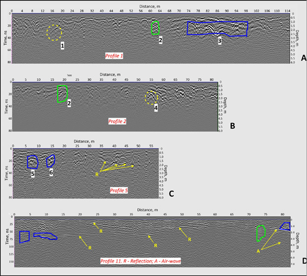
Fig. 9. GPR survey results from the courtyard of Medzhybizh Castle. Examples of radargrams with characteristic anomalies explained in the Legend of Figure 11. The positions of the corresponding GPR profiles are shown in Figure 8.1.
9 pav. Medžybižo pilies kiemo tyrimų georadaru rezultatai. Radarogramų pavyzdžiai su būdingomis anomalijomis, jos paaiškintos 11 pav. legendoje. Atitinkamų GPR profilių padėtis pažymėta 8 pav., 1.
In Figure 9, a–d, the reflections, which could be attributed to the shallow stone structures, are identified because there is a significant difference in dielectric permittivity between the soil and the stones. Radargram from Profiles 1 and 2 (Fig. 9 A,B) revealed responses marked 1 and 4 originating from ‘other objects’, which were recommended for excavation.
There are several linear reflections on the radargram at Profile 11, which may indicate the level of refilling the area.
The results of our GPR measurements revealed the continuation of the Western Wall, known from the earlier excavations (Толкачов, Купрій, 2021), while stone structures in the proximity of the Carriage House and the Southern Wall show up as intense reflections.
The GPR time slices of the Courtyard (Fig. 8.3) indicate numerous structures, yet not all of them can be provided with an unambiguous interpretation based on the current knowledge. A fragment of a utility pipe at the center of the measured area can be identified by a pronouncing linear reflection in a time slice from 70 cm. As mentioned above, this pipe was used to estimate the average velocity of the electromagnetic wave in the ground (0.1 m/ns). A slightly more reflective area at the Northeastern corner probably indicates lower soil dielectric permittivity due to specific land use in the past (gardening?). The area to the West and North of the church was marked as a cemetery after partial excavation in 1993 (Толкачов, Крамарова, 2011). Reflections appear due to rubble left after rebuilding the church and later used to backfill the grave pits. The Western part is supposed to be younger than the Northern one, as corresponding anomalies appeared at a depth of 70 cm.
Time slices of the courtyard in the depth interval of 1.6–2.8 m show no anomalies except for the area adjacent to the bridge. There is a П-shaped feature located in front of the bridge. Its possible interpretation is a lift bridge counterweight chamber. It was accessed from the underground in 2016 during the archaeological investigation of the gate.
Linear anomalies along the Northern and Western walls show a faint contrast with the background on the time slice of 3.0 m, which is suggested to be sourced from stone walls and structures.
GPR measurements inside Sieniawski’s Palace were conducted by a series of profiles, as shown in Fig. 8.2. Radargrams collected along profiles S0 and S4 show linear anomalies associated with the contrast structure 7, which was initially interpreted as a wall. It shows up in this particular way due to the parallel position in relation to these GPR profiles. The hyperbolic anomalies at 42 ms in Profiles S5 and S6 are interpreted as reflections from the ‘wall-like’ structure 7, as the profile is located perpendicular to it.
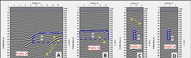
Fig. 10. GPR survey results from Sieniawski’s Palace. Examples of radargrams with characteristic anomalies are explained in the Legend in Fig. 11. The positions of the corresponding GPR profiles are shown in Fig. 8.2.
10 pav. Tyrimų georadaru rezultatai iš Sieniawskių rūmų. Radarogramų pavyzdžiai su būdingomis anomalijomis, jos paaiškintos 11 pav. legendoje. Atitinkamų GPR profilių padėtis pažymėta 8 pav., 2.
Fig. 11 shows all the structures interpreted with the help of GPR radargrams and C-scans, which is a base for further excavations and speculations around their origin and chronology of the Castle.
Fig. 11. Lithuanian Castle superimposed on the modern plan of Medzhybizh Fortress. Interpretation scheme of GPR survey results.
11 pav. Medžybižo pilies lietuviškoji dalis, pažymėta dabartiniame pilies plane. Tyrimų georadaru rezultatų interpretacinė schema.
The boundaries of excavations are indicated in red in Fig. 11. In the sector of anomaly 1, a rectangular arched masonry building with dimensions of 6.4×5.4×2.8 m was uncovered. The final point of research was the cellar of the Oficyna. It was mentioned in the Inventories of Medzhybizh Castle dating back to the 18th century. In 2022, archaeological stripping and conservation of the object was realized.
Anomaly 2 records the central part of the Western Wall of the Lithuanian Castle (see Fig. 12.2). The surface of the Western Wall was in the zone of excavations and test pits at different times. Hence, its structure has been traced in general. According to the results of archaeological research, the plan of the wall corresponds to the scheme of the Lithuanian Castle, which was drawn by E. Lopushynska.
Fig. 12. Anomaly 2. Objects outside of the Western Wall (central sector). Section 12.1. Ground cemetery. Section 12.2. Outer contour of the Western Wall.
12 pav. Anomalija 2. Objektai vakarinės sienos išorėje (centrinėje dalyje). 1 – kapinės. 2 – vakarinės sienos išorinis kontūras.
In zone 3, in the central part of the Lithuanian Castle, an unknown masonry structure measuring a total length of 36 m was discovered. It is located along the Northern façade of Sieniawski’s Palace (Figs. 13.1, 13.4). The structure is built like a wall which is 1–1.5 m wide. From the Southern side, it rests on nine brick rectangles measuring 2×1 m. They are designed together with the Northern façade of the Palace. The building is constructed of natural limestone blocks. Its masonry is made with clay and limestone mortar. According to archaeological stripping in two sections at the bottom of the structure, it is possible to state that it has a height (or depth from top to bottom) of 5–6 m (Figs. 13.2, 13.3). One more feature of this facility is a colonnade platform along the Palace façade. On top of the structure, there were two lower parts of columns which were carved from limestone. The object was discovered and studied in 2019–2021.
Fig. 13. Object detected at the site of anomaly 3. The wall with buttresses is located along the façade of the palace. Section 13.1. Western part of the excavation. Section 13.2. Excavated part of the wall (depth 5 meters). Section 13.3. Buttress of the wall, built from the façade of the Palace (depth 5 meters) (Photo by V. Vietrov).
13 pav. Anomalijos 3 vietoje aptiktas objektas. Siena su kontraforsais prie rūmų fasado. 1 – vakarinė kasinėjimų dalis. 2 – atkasta sienos dalis (gylis 5 metrai). 3 – sienos kontraforsas, pastatytas prie rūmų fasado (gylis 5 metrai) (V. Vietrovo nuotr.).
Anomaly 4 recorded an arched masonry structure. That was partially filled with soil and construction debris. The object is an arch gate. It is built into the Eastern Wall of the Lithuanian Castle between two buttresses 10 meters East of the Eastern Building. Adjacent to the arch is an arched masonry underground passage, which goes from the Eastern Wall to the West into the Lithuanian Castle. The height of the structure is 2–2.5 m, and it is 2–3 m wide. These data are approximate because the object has not been investigated yet. It was believed that the length of the passage was no more than 10 meters, but the radargram recorded an anomaly several meters further in the Westerly direction. In 2021, under archaeological supervision, a trench for laying modern communications up to 3 meters deep was made. The edge of the trench determined that the length of the masonry structure is more than 12 m. Thus, this previously unknown part of the structure was recorded on the radar.
Anomalies 5 and 6 are located 60 meters West of the Western Wall of the Lithuanian Castle. When planning the location of the stratigraphic sections in 2020–2021, we took into account the radar survey data and planned the stratigraphic trenches in such a way that they would include anomalous zones. In 2021, we laid two stratigraphic sections with a length of 18 m and a depth of 3–4 m. Fragments of rubble masonry on limestone mortar were recorded in the Southern part of the Western section. In its cross-section, the masonry measures 3.0×1.5 m. At a distance of six meters to the Northeast, another rubble masonry measuring 1.0×0.5 m was recorded. We can see that both masonry structures are later in terms of the timeline. They cut through the 12th–15th century layer, destroying it. Their archaeological stripping gives a clear idea of what the late objects in the layer of the Lithuanian Castle’s existence would look like.
Anomaly 7 is located within the Southern Building of the Lithuanian Castle. It was discovered during radar surveying in the Southeastern part of the basement (underground) tier of Sieniawski’s Palace. The radargram was interpreted as a wall running from East to West, parallel to the South Wall. To fix the found object, a 6×2 meter trench to a depth of 1.5 m was laid across its long axis (Fig. 14).
Fig. 14. Anomaly 7. Anomaly sizes are indicated with tape. Section 14.1. Western side of the trench. Section 14.2. Vertical cracks along the edges of the anomaly. Section 14.3. Eastern side of the trench. Section 14.4. Crack along the Southeastern edge of the anomaly (Photo by V. Vietrov).
14 pav. Anomalija 7. Anomalijos dydis matomas liniuotėje. 1 – vakarinė perkasos pusė. 2 – vertikalūs įtrūkimai išilgai anomalijos kraštų. 3 – rytinė tranšėjos pusė. 4 – plyšys palei pietrytinį anomalijos kraštą (V. Vietrovo nuotr.).
Excavations determined that the anomaly indicated a section of loess soil of a width of 1.3 m. The section is observed in both walls of the trench (Fig. 14). Its boundaries are marked by vertical cracks in the loess soil. These cracks can be seen especially clearly on the Western side of the trench (see Figs. 14.1, 14.2). The internal volume, between the cracks, is extremely dense.
During the restoration and museumification of medieval castles, decisions are mainly made and substantiated by archaeology data. Usage of GPR scanning is an integral part of the current level of archaeological research. In connection with this, several methodological and exclusively technical issues arise. In the course of the archaeological research in Medzhybizh Castle (a monument of archaeology and architecture of the 12th–18th centuries), work in this direction has been done. The work was complicated by multiple changes in the architectural plan of the Castle and its Courtyard. The level of the daytime surface in some areas has changed by 3–8 m over the past 500 years. The use of ground-penetrating radar scanning data has significantly contributed to the planning of archaeological excavations. Also, when carrying out geophysical and archaeological works, questions arose concerning the accuracy of topographic references and their correlation with satellite survey materials.
The use of the ground-penetrating radar in the research on the core and the site in the Western part of the Lithuanian Castle provided extensive information and raised various questions. Most of these problems can be solved only by field archaeology. Of course, it is desirable to excavate the entire area of the Castle yard. However, considering the 3D model of the Lithuanian Castle, where the current level of the soil is shown with a red ribbon (see Fig. 2), it is easy to understand how grandiose the task is. In this way, the ground-penetrating radar makes it possible to obtain at least partial information about objects buried in this layer of soil.
In this regard, interpretations of objects associated with the Southern Building (anomalies 3 and 7) are promising. Anomaly 3 recorded the huge stone wall, resting on nine 2.0×1.2 meter rectangles built into the structure of the Northern façade of the Southern Building. Its length is 36 meters, and it is 5 meters high. The dating of this structure brings us to the 14th–15th century, which can be based on the analysis of construction technologies. The wall masonry is mainly made of clay mortar. However, we do not find such archaic technology in the building structures of Medzhybizh Castle of the 16th–18th centuries.
The South House itself (and later, after the construction of two more floors, Sieniawski’s Palace) was built between two long parallel walls – the Northern façade (represented by a double wall – see anomaly 3) and the Southern Wall. Probably at the time of its construction and existence, the Southern House had a different internal layout than the modern basement floor of Sieniawski’s Palace. This assumption is related to the interpretation of anomaly 7. Compaction of the soil and cracks in it (Fig. 14) is associated with a significant external load on the soil. The linear nature of the anomaly, its width of 1.3 m, and the orientation of the long axis parallel to the Southern Wall, indicate the probability of the existence of a stone wall here, which imposed a load onto the soil. Due to this load, cracks appeared in the soil. Over time, during the redevelopment of the building, the wall was dismantled, and we are left with only specific damage to the soil. We can say that, with the help of the GPR, we saw ‘a shadow’ of the former wall. It is also possible that the destruction of soil may be the remains of a shallow building pit of the wall, which was filled with the same loess soil later. As for the dimensions of the wall, based on the size of the anomaly, the width of 1.3 m is ordinary for buildings of that time. However, the length of the anomaly, which is about 20 m, may not be the total length of this wall. The Eastern end of the anomaly, if it extended beyond the boundaries of the Palace, could have been destroyed during the archaeological stripping of the space between the Palace and the tower in 2019. At the time of GPR surveys, the ground level between the Eastern wall of the Palace and the Eastern Tower was already significantly below the anomaly marks. As for the Western end of the anomaly, it was likely destroyed during the archaeological stripping of the basements in 2017. The fact is that, in terms of the task of the restorers, the soil from the basement was selected to an artificial level that corresponded to the doorways of the 16th and 17th centuries. At the same time, the Palace is located on a site which features a natural bow to the East and South. During the construction of the Southern Wall, the height difference of the hill was levelled by gradually lowering the level of the foundation by ‘steps’, the depth of which corresponded to the terrain. Thus, in the 14th and 15th centuries, the level of the soil on the floor in the Southern Building was completely different from that of our time (i.e., if comparing the present with the 16th and 17th centuries). This hypothesis is confirmed, for example, by the absolute heights of the lower level of the loopholes of the 15th century preserved in the Southern Wall (in the space of the Southern Building). Counting from East to West, the level of the loopholes is 275.9 m, 276.1 m, 276.4 m, 278.1 m, and 278.2 m. That is, the drop in the level of the floor of the South Building from East to West in the 14th and 15th centuries was about 3.5 meters, with an increase in the level towards the West. Thus, the Western end of the anomalies was probably destroyed by us during the levelling of the modern floor of the Palace. So, it is likely that the wall (which destroyed the soil under it) was dismantled over time when the internal layout of the Southern Building was changed. It is not unusual that, at the first stage of construction, instead of the Southern Building, there could have been a long Barbican in this place. It went from the Eastern Tower to the Western Gate of the Lithuanian Castle. Thus, the indicated wall could actually be the Northern Wall of the long Barbican.
Anomaly 4 is represented by a gate with a masonry passage. The total length of the object is currently unknown. The masonry passage may continue into the middle of the courtyard of the Lithuanian Castle. However, it should be noted that this construction probably cannot be dated to the 14th–15th centuries. The lower level of the gate and the masonry passage are several meters higher than the level of the ‘daylight surface’ of the courtyard in the 14th and 15th centuries. The masonry structure itself can be dated to approximately the 18th century. This system was used to drain surface water from the courtyard of Medzhybizh Castle. It has been performing this function until now.
Anomalies 5 and 6 have a clear interpretation. They are not related to the time of existence of the Lithuanian Castle. These are fragments of the basement of a dwelling near the defensive wall, mentioned in the Inventories of Medzhybizh Castle in the second half of the 18th century. This entity existed until the beginning of the 20th century. For us, the study of its basement is important from the point of view of construction methods. It is also significant to see what the later structures, cutting into the stratigraphic horizons of the 15th and 17th centuries, would look like.
A series of anomalies on site 2 can be considered the most complex issue to be interpreted. The close location of the fortification ditch, the Western Wall of the Lithuanian Castle, the soil burial ground and the underground masonry passage significantly complicate the interpretation. Undoubtedly, there is a need for continued field work. Previous studies have not determined the time of existence and the functional purpose of the stone structure with the underground gallery. Perhaps this is the stone plinth of the Tower, which was part of the defensive system of the Lithuanian Castle.
A masonry stone cellar is anomaly 1. Judging by the materials of its excavations, it dates back to the 18th century. However, its location (in the middle of the defensive ditch of the 12th–15th centuries, or in close vicinity to this timeframe) raises questions requesting a more detailed field study of this area.
GPR survey was capable of seeing elements of the ancient architecture of Medzhybizh Castle under up to 3 m thick horizon of debris and soil. Careful comparison of geophysical and archaeological investigations created a base for delineation of a possible area used and built up near the castle in the Lithuanian period.
We believe that the recent findings will help to draw the attention of the State Cultural Administration bodies to geophysical methods as important tools to verify the structure and reveal the presence of possible hidden elements in architectural monuments, thereby contributing to their proper restoration.
References
Bondar, K.M., Vietrov, V.S. 2023. Geophysics reveals hidden architecture of the Medzhybizh Fortress, Ukraine. ISAP news. The Newsletter of the International Society for Archaeological Prospection, 69, pp. 4–10.
Conyers, L.B. 2017. Ground-penetrating Radar. In: A. Gilbert, ed. Encyclopedia of Geoarchaeology. Springer Reference. Heidelberg, London, New York: Springer, pp. 367–379.
Conyers, L.B. 2012. Interpreting Ground-penetrating Radar for Archeology, 1st Edn. Left Coast Press, Walnut Creek, California.
Daniels, D. J. 2004. Ground Penetrating Radar, 2nd Edition. The Institute of Electrical Engineers, London, United Kingdom.
Kuncevičius, A., Laužikas R. 2012. The Excavation of the Radziwiłł palace at the Dubingiai Castle site. In: G. Zabiela, Z. Baubonis, E. Marcinkevičiūtė, ed. Archaeological investigations in independent Lithuania. 1990-2010, transl. J. A. Bakanauskas. Vilnius: Lietuvos archeologijos draugija, r. 237.
Peskova, A. ed., 2020. Medieval “Izyaslavl’”: The Large Fortified Settlement near Shepetovka, in the light of archaeology. Volume 1. Materials from the archaeological excavations of Mikhail Karger 1957–1964 investigated in the 1960s–1980s. St. Petersburg: NestorHistoria, 264 p., il. (Proceedings of IHMC RAS. Vol. LV)
Transient Technologies LLC 2004, Software. Synchro Program [online] (Last updated in 2024) Available at: <http://viy.ua/e/software/synchro.htm> [Accessed 16 July 2024]
Trinks, I., Hinterleitner, A., Neubauer, W., Nau, E., Löcker, K., Wallner, M., et al. 2018. Large-area high-resolution ground-penetrating radar measurements for archaeological prospection. Archaeological Prospection, 25(3), pp. 171–195.
Vietrova, Т., Snitko, І. & Vietrov, V. 2021. The results of preliminary architectural and archaeological research of the Pentagonal Tower of the Medzhybizh Fortress. Arheologiia & Fortificatsiia Ukrainy. Kamianets-Podilskyi: FOP Buynytskyi O. A., pp. 204-208.
Zabiela, G. ed. 2012. Archaeological investigations in independent Lithuania: 1990-2010. Vilnius: Society of the Lithuanian Archaeology.
Альбом архивных материалов по памятнику архитектуры XIII-XIX вв. - замку-крепости в Меджибоже, 1970. Киев: Гос. комитет Совета Министров УССР по делам строительства. Украинское специальное научно-реставрационное производственное управление, 43 с.
Кахлі Волині XV-XVIII ст., 2018. Каталог виставки. Корнин: ПП Дятлик М.С., 27 с.
Лопушинская, Е. И., Шелягов, В. С., Удовиченко, А. Г., Кривуца, С. Г., Козленко, С. П., Корнич, О. Ю. 1990. Крепость-музей в пгт. Меджибож, Хмельницкой обл. Дворец. Комплексные научные изыскания. Архитектурные натурные исследования. Шурфы, зондажи. Киев: Гос. комитет Совета Министров УССР по делам строительства. Украинское специальное научно-реставрационное производственное управление.
Пономарева, Л. 1971. Историческая справка по замку-крепости в пгт. Меджибоже Хмельницкой области. Памятник архитектуры XIV-XIX в.в. нач. НИРО №4 Е. Лопушинская; мл. науч. сотр. Л. Пономарева. Киев: Гос. комитет Совета Министров УССР по делам строительства. Украинское специальное научно-реставрационное производственное управление, 35 с.
Стопенчук, С. 2021. Знахідки арбалетних наконечників на території Меджибізької фортеці утпольовому сезоні 2017 року. Науковий вісник «Межибіж», 1–2, с. 153–161.
Толкачов, Ю. 2010. Меджибізький замок. Київ, ФОП Поліщук О. В., 150 с.
Толкачов, Ю., Крамарова, С. 2011. Середньовічний могильник у Меджибізькій фортеці. Археологія і фортифікація Середнього Подністров’я. Збірник матеріалів. Кам’янець-Подільський: ПП «Медобори 2006», с. 74–81.
Толкачов, Ю., Купрій, С. 2021. Меджибізький замок – прикордонне стратегічне укріплення Великого Князівства Литовського (до питання про використання арбалетів на Україні ХІVХVІ ст.). Науковий вісник «Межибіж», 1–2, с. 128–133.
Viktor Vietrov, Kseniia M. Bondar
Summary
This study focuses on geophysical measurements and archaeological proof of buried structures in Medzhybizh Castle (Western Ukraine). Architectural and restoration studies over the course of more than 50 years have revealed part of the Castle built in the 14th and 15th centuries. Supposedly, it is associated with the Lithuanian period of the Castle’s development. The main problem in studying the Lithuanian Castle is that, during the redevelopment of the Courtyard surface from the 16th to the 18th centuries, all objects in the Eastern part of the fortress were covered with soil. Currently, they are hidden in a depth of two to eight meters.
The conventional methodology used to delineate the construction stages of the Medzhybizh Castle, relying on limited archaeological excavations conducted between 1985 and 2022, is inadequate for capturing the complete subterranean heterogeneity. This deficiency has resulted in restoration errors and an assorted representation of the architectural ensemble of Medzhybizh Castle.
This was the reason to apply GPR scanning in the courtyard area and inside buildings. By now, we have already conducted two GPR surveys on the courtyards of the Castle, including its Lithuanian part.
GPR measurements were conducted with the use of a dual-frequency (300 MHz and 700 MHz) instrument. The GPR survey was capable of seeing elements of the ancient architecture of Medzhybizh Castle under a horizon of debris and soil up to 3 m thick. In the radargram crossing the courtyard, several linear reflections can be seen, probably marking the levels of backfill material. Possible structures of the Lithuanian Castle were suggested from radargrams and later excavated. Among them, the most prominent element is the Western Wall of the Lithuanian Castle, known from excavations of previous years. In the Courtyard of the Castle, a complex 36-meter-long wall structure was found stretching along the Northern façade of the Palace. Pavements and foundations of buildings of an unspecified purpose were recorded near it; as of today, full-scale excavations have not yet been carried out there. A GPR survey on the modern floor of the Palace revealed the presence of linear structures at a depth of 1.8 m below the floor.
The presence of artifacts from the 14th–15th centuries in the excavations confirmed that we are excavating objects related to the Lithuanian period of the Castle’s existence. GPR has identified architectural objects from a later time as well, which also fall into the study area and require special attention.
Viktor Vietrov, Kseniia M. Bondar
Santrauka
Straipsnis pristato Medžybižo pilies (Vakarų Ukraina) geofizikinius tyrimus ir identifikuotas archeologines struktūras. Daugiau kaip 50 metų trukę architektūriniai tyrimai ir restauracijos darbai atskleidė XIV–XV a. statytos pilies dalį, kuri, kaip manoma, yra susijusi su lietuviškosios pilies raidos laikotarpiu. Pagrindinė problema tiriant lietuviškąją pilį yra tai, kad XVI–XVIII a., pertvarkant pilies kiemo paviršių, visos rytinės pilies dalies struktūros buvo užverstos žemėmis. Šiuo metu šios struktūros yra dviejų–aštuonių metrų gylyje.
Įprastai Medžybižo pilies statybos etapai buvo nustatomi ribotais archeologiniais tyrimais, kurie buvo atlikti 1985– 2022 m. Tokia metodika yra nepakankama, kad užfiksuotų visą po žeme slypinčių struktūrų įvairovę. Šis trūkumas lėmė restauravimo klaidas ir problemišką Medžybižo pilies architektūrinio ansamblio vaizdavimą.
Dėl šios priežasties kiemo teritorijoje ir pastatų viduje buvo nuspręsta taikyti skenavimą georadaru. Iki šiol atlikti du tyrimai georadaru pilies kiemuose, įskaitant lietuviškąją jos dalį.
Tyrimai georadaru buvo atlikti naudojant dviejų dažnių (300 ir 700 MHz) prietaisą. Atliekant matavimus pavyko identifikuoti Medžybižo pilies architektūrinius elementus, kuriuos yra užkloję iki 3 m storio nuolaužų ir grunto sluoksniai. Radarogramoje, kertančioje kiemą, buvo matyti keli linijiniai atspindžiai, greičiausiai žymintys užpylimo lygius. Iš radarogramų nustatytos galimos lietuviškosios pilies struktūros, kurios vėliau buvo archeologų kasinėtos. Tarp jų ryškiausia yra lietuviškosios pilies vakarinė siena, žinoma iš ankstesnių metų kasinėjimų. Pilies kieme rasta sudėtinga sienos struktūra, besitęsianti palei šiaurinį rūmų fasadą, 36 m ilgio. Šalia jos užfiksuotas grindinys ir nenustatytos paskirties pastatų pamatai. Šioje vietoje dar nebuvo atlikti detalūs archeologiniai kasinėjimai. Atlikus tyrimą georadaru dabartinių rūmų grindyse, 1,8 m gylyje po grindimis aptiktos linijinės struktūros.
Tai, kad archeologinių tyrimų metu rasta XIV–XV a. radinių, patvirtino, jog identifikuoti objektai yra susiję su lietuviškuoju pilies gyvavimo laikotarpiu. Georadaru nustatyti vėlesnio laikotarpio architektūriniai objektai, patenkantys į tyrimų teritoriją, taip pat reikalauja dėmesio.